Bog Standard – Nine Standards Rigg

IMG_8789

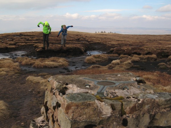
Jumping in the peat bogs with Nine Standards Rigg in the background

The Stats:

Area: Kirby Stephen and Hartley

Distance: 9.5 miles

Time taken: 5 hours

The Review:

The previous two Easter walks with my friend Guy have been huge successes. Arguably the greatest of them all was Buckden Pike, a splendid walk on a splendid day. Wether Fell, last year’s walk, wasn’t bad either, with great weather and a surprisingly good summit. So today’s walk, Nine Standards Rigg had a lot to live up to. However, our expectations weren’t high. As seen from a quick Google, Hartley Fell (which is the hill the Nine Standards Rigg sits on) looks like any other bleak moorland. The Nine Standards themselves are no more than nine stone pillars. The back story is moderately interesting (Wainwright once said they could have been built to make Scottish invaders think there was an English camp on the hill. Actually, it was probably built to mark the Yorkshire-Cumbria), but not enough to merit its bleak surroundings. So we came with low expectations, although that may not have been a bad thing.
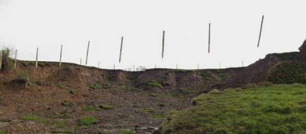
IMG_8769

The suspended fence

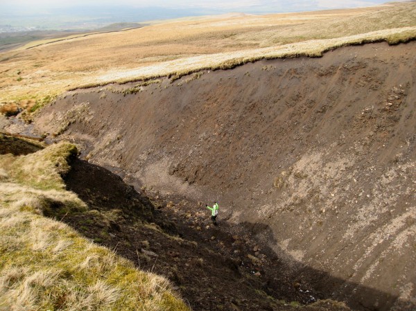
You see, if you come with low expectations, any moderately good section of a walk is made even better. However, the first part of the route in any view was more than “moderately good”. Obviously, this was the bit when we weren’t climbing the Rigg. Instead we wondered from Hartley over fields and into a little wood, following a treacherous and winding path. We started the walk by marvelling at the legendary “suspended fence”. As we would also see later on in the walk, there had been many landslips in the area over the last month. This was made clear to us by the way a fence was partially suspended in the air after the land had slipped away beneath it. The whole length of the fence looked unmoved and untouched, as if it had been built after the landslip had occurred. It was bizarre, and certainly made us chuckle.
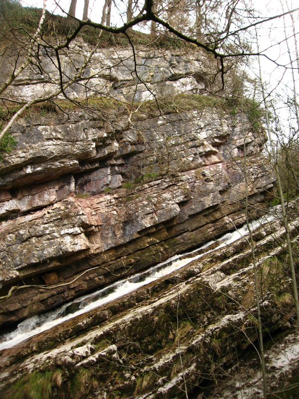
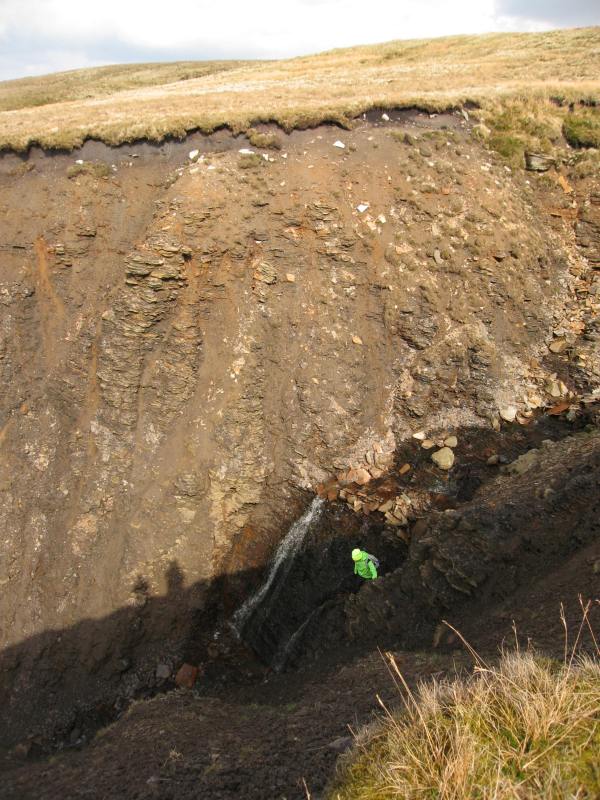
IMG_8770

The “waterfall”

Later landslips proved a problem when we got into the trees. They had caused path erosion and fallen down trees, yet none of such obstacles stopped us from continuing with the walk, even when a sign said that the path was closed. We continued along the increasingly slippery path to find a “waterfall” as described in the instructions. I write “waterfall” in speech marks because it seemed more like a waterslide, or, as Dad eloquently described it: “its a waterfall that thinks its a conveyer belt.”

IMG_8780

The last approach up to the Rigg

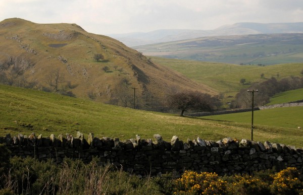
After the woods, we faced a mountain and a decision. We could either “scramble” (more misdirecting vocabulary from the guidebook. It was more like a steep plod) up a grassy, barely-worth-mentioning hill, or walk around the hill. The clear choice was the latter, and we were glad of our route, because we later found out that the unworthy hill that we saw was just a foothill of a different, impressive but nasty-looking hill (or should I say mountain).

IMG_8787

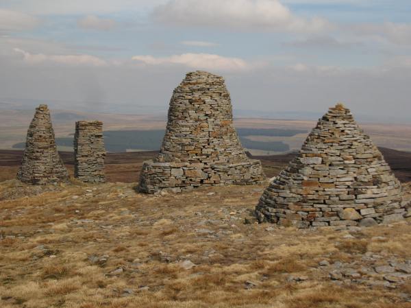
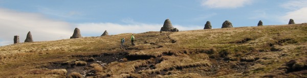
Four pillars on Hartley Fell

We walked all the way around the hill to Ladthwaite Farm. From there, we walked up to the base of the great Hartley Fell. Upon first sighting of Nine Standards, it looked miles away. It had felt like we’d made good progress, but we’d only walked 3 1/2 miles and it didn’t look like we were going to reach the Rigg anytime soon. We headed up the coast the coast, directly towards the stones. The peat bog wasn’t as bad as we were expecting and, although it got worse at the very end, we finally arrived at the Rigg. There we had lunch and admired the views. The weather for more or less the entire day was much better than we were expecting, which made the walk all the more enjoyable. The views were expansive but not spectacular, which was pretty much what we were expecting. We walked along the brow of the hill towards the trig point, and after jumping up and down in the mud we made the long way back down.

IMG_8796

The moment before Guy makes his move down the waterfall

IMG_8797

He survives, somehow

The descent of Hartley Fell was much more difficult than the ascent. It was manageably boggy but the main problem with the bogs is that they made the route difficult to find. We eventually found ourselves going off-piste, which was OK because we knew we’d intersect the main track eventually.

Actually, it may have been a blessing in disguise. We cut off a corner of the main route and Guy successfully scrambled down a waterfall (a real one this time) in a gulley. We eventually reached the path and got back on track.

IMG_8773

A view of the hill we almost climbed on the way down from Hartley Fell

The final part of the walk was a 2 mile walk along the road. Although this was boring, it meant that we could get going without having to worry about navigation. By this point, our legs were getting tired anyway, and the road continued to gradually descend back into the village of Hartley.

And so ended the walk. One to compete against the previous two Easter walks? No chance, but it wasn’t a bad day out either.

Conquering the Crinkles – The Lakes Part 2

Soaking up the views on Crinkle four

Soaking up the views on Crinkle four

Stats

Mountain(s): Pike o’ Blisco and Crinkle Crags

Height(s): Pike – 705m, Crags – 859m (the highest was the second crinkle)

Distance: 8 miles

Time taken: 8 hours

Review

The Crinkles were our second challenge of the holiday after the success of the Langdale Pikes the day before. We were soon to discover that this one was to be just as exciting and enjoyable.

On the banks of Pike o' Blisco looking over to the Langdale Pikes

On the banks of Pike o’ Blisco looking over to the Langdale Pikes

In contrast to the day before, we turned right from our tent heading directly up the banks of Side Pike (which we did have a think about bagging but in the end decided it was a waste of time) across a road and directly toward the looming Pike o’ Blisco. The path was far from clear but a good bit of map-reading skills from Dad soon got us on track. So, after pushing through relatively thick fern for 45 minutes we were glad to have a rest as the path became more substantial. There was only one way we were heading: up!

Summiting Pike o' Stickle

Summiting Pike o’ Stickle

The ascent up Pike o’ Blisco was a punishing one but not as long as the one to Pavey Ark and more pleasurable. There were good view across to the rest of the Langdale Pikes as well. Once over the disappointment of a false summit we reached the top of the hill although we did have to do a final 0.5 mile scrambling across boulders near the summit. Towards the end of the climb we did feel like the summit had somehow dissappeared or that we’d passed it. But after plodding along this barren but not ugly landscape we finally reached we summit and the views opened out. The summit was a nice one; a bold pyramid of rock topped by a cairn that looked rarther sorry for itself.

Sheep enjoying the view on Crinkle two.

Sheep enjoying the view on Crinkle two.

Once summiting the Pike and taking in the views we headed the long way down towards the five crinkles. The summit of the Pike was a good vantage point to see the clear path up and behind Great Knott. We descended gradually by a knee-hammering, occasionally unclear and bouldery path. At the bottom of our slight descent was a crossing point in paths accompanied by the relatively unattractive Red Tarn. From there we headed straight forward to the crag often mistaken for a Crinkle – Great Knott.

As written in our Wainwright guidebook that we had to hand, the needle shaped Glagstone’s Finger lurked amongst the face of the crag. In the tent the night before it seemed an inviting prospect to go clambering amongst the shapley rock in search of a natural wonder. It turned out when we were there the idea seemed to extravagant as the Knott looked unforgiving and had a lack of paths.

Giving Gladstone’s Finger a miss we pressed on at speed to Crinkle number one on which we decided to have lunch. The climb to the Crinkle was simple although we kept thinking we’d found the summit cairn before we found another cairn that was higher but eventually we were satisfied with a true summit and sat down looking over part of the Scafell Range (we saw the full range later on) and east coast – yes, we could even see the sea and the Isle of Man!

IMG_6310

The tarnlet on Crinkle three. The summits from left to right are Scafell Pike, Ill Crag, Broad Crag, Great End and Bowfell

After finishing off our freshly made tuna sandwiches we descended the first Crinkle looking out for the summit of the second Crinkle and the famous (more like infamous) Crinkle Crags bad step. We soon found that both were hard to miss. Having previously scaled the Blencathra bad step (see the “Rankings” page for the link to the full post) I was looking forward to at least having a look at this beast. The bad step was even crowned by Wainwright as the most difficult to pass fell-walking object in the Lakes. Initially all that we were planning to do was to admire the two slabs shoved into the rockface to deny easy acsess to the obvious route up the crag. But after seeing a man Dad’s age and a girl my age climb it successfully we crazily decided to give it a crack. And so, a bit of huffing and puffing later we found ourselves standing above the bad step. From there on it was plain sailing and easy scrambling to the summit of Crinkle 2.

And what a summit it was! The summit of the Crinkles had it all: the large cairn, obvious photo point, gorgeous tarnlet and panoramic views. Bliss! But we knew yet more Crinkles were to be summited and after the second they came thick and fast.

The beauty of Crinkle Crags is that once you’ve reached one Crinkle you can see the one that you’d climbed previously, thinking back to those incredible views,

Our descent path left of the river and The Band at the bottom right

Our descent path left of the river and The Band at the bottom right

and you can see the next Crinkle, itching to get bagging summit after summit. And also, there’d be hidden gems lurking around the cliffs. Adam-a-cove for instance; a strange outcrop of rocks situated on the summit of the forth Crinkle. Never has there been a walk I’ve been on packed with so many views. Once your up there you don’t know where to look – the visibility was excellent.

After the fifth Crinkle came the less exciting Shelter Crags, which from below look like a set of larger, lumpier and less exciting Crinkles. And when on them they’re not any better. Despite saying that, some interesting outcrops of rock became the last hurrah before the long descent. At the Three Tarns (the point at which we turned down into the valley) we had to make the decision whether or not to go back via a hummock called The Band or by Hell Gill slightly south of The Band. And as we may have ascended The Band the next day in order to summit Bowfell we turned down the much less clear, boggier, steeper, less dramatic and, as Wainwright said, not to be preferred to The Band.

So the slow descent began and at the end we calculated that I had been waiting for Dad a total of one hour (that’s all my rests waiting for put together). The walk down was not unenjoyable, just that it was very slow and painful for Dad.

Once we’d finally reached the bottom it was a fairly straight forward final stretch. We weren’t too sure with Wainwright, who said that you could go down a shortcut past a farm down what looked on the map as a private road. Thankfully when we got there there were plenty of sign saying “path” leading us in right direction.

And finally, after a slow but hearty meal of bangers and mash, the day ended tucking up in a warm, cosy bed, looking forward to waking up to the beautiful Lakeland fells in the morning.

Summiting the Stickles – The Lakes Part 1

Me and Dad on Pike o' Stickle with Harrison Stickle behind

Me and Dad on Pike o’ Stickle with Harrison Stickle and Lake Windermere behind

The Stats

 Mountain(s): Pavey Ark via Jack’s Rake, Harrison Stickle, Thorn Crag (not summited) and Pike o’ Stickle

 Height(s): Pavey Ark: 700m – Harrison Stickle: 736m – Pike o’ Stickle: 709m

 Distance: 8 miles

 Time taken: 7 hours

The Review

It’s been a long (long) time coming but I am back on the blog with the latest hill-walking heroics from our 2014 camping trip to Langdale. The trip in general was extremely successful with similarly stunning weather as last year trip up Haystacks and Scafell Pike (but not quite so warm!). This year’s duo was the Langdale Pikes and Crinkle Crags (which I will do in my next post). Both ended up ranking in my top 3 best ever walks; for full listings see the “Rankings” page. Next year we plan to head north to bonnie Scotland and Loch Lomond and the Trossachs National Park to tackle Ben More and The Cobbler.

IMG_6245To climb the Langdale Pikes and Jack’s Rake became the main aim of the holiday after we agreed to leave Helvellyn for another year (possibly 2016). We had arrived at the surprisingly busy Great Langdale campsite the day before and took a leisurely 4 hours setting up. We never had to drive the car all holiday and soeach walk started literally from our tent. The walk began with an easy stroll along the valley to the new Dungeon Ghyll hotel. This is where many non-campers parked and where hoards of fell-walkers started the walk.

At Stickle Tarn and Pavey Ark. Look carefully and you will see Jack's Rake cutting across the cliff from the bottom right to the top left.

At Stickle Tarn and Pavey Ark. Look carefully and you will see Jack’s Rake cutting across the cliff from the bottom right to the top left.

Indeed, the initial ascent was rather Ben-nevis-tastic; good views across Langdale but a steep climb and ruined by the constant flow of people. For me and Dad the ascent seemed to go on for ages but we were soon to find the it was well worth it.

Scrambling up a challenging and exposed section of Jack's Rake on the dramatic, scarred face of Pavey Ark

Scrambling up a challenging and exposed section of Jack’s Rake on the dramatic, scarred face of Pavey Ark

We followed a slightly boggy path towards the north end of the tarn and then tackled a scree slope, which wasn’t as steep as it looked. Here was the true start of my first graded scramble. I lead the way in order to give Dad commentary during tricky sections. The first section was easy scrambling with the occasional trickle of water spilling across the rake. The first tricky squeeze and real challenge of the day came just before the lone Jack’s Rake tree. I just about managed to get up it and Dad made it (with a bit of guidance) and we both enjoyed our first view across Stickle Tarn. There were 3 or 4 more of these scary (but not exposed) squeezes to come.

Arguably the hardest section on Jack’s Rake was trying to get past the infamous obstacle simply named “The Gun”. It took me a minute or so to get past this challengingly placed rock. I made it to the expense of the knocked knee and Dad conquered it after passing all his bags and his stick up to me.

Squeezing past "The Gun"

Squeezing past “The Gun”

The final hair-raising bit of the climb came during the final few move. It was a smooth rock that had to be scrambled on but had a vertical 100ft+ drop beneath it. Of course, we both climbed it, stopping ourselves from looking down.

We then had lunch and joined the main path to Harrison Stickle – the highest of all the Langdale Pikes. We completed a simple scramble to the summit plateau and enjoyed a stunning panorama view back to Pavey Ark across the Langdale valley and on to Pike o’ Stickle. Reaching the summit was a magical moment.

We pressed on and off Harrison Stickle to a crossing point amongst the pikes. Here we decided whether or not we should bag Thorn Crag. In the end we decided not to as it turned out to be a much longer walk than what we had expected.

The view of Pavey Ark from Harrison Stickle

The view of Pavey Ark from Harrison Stickle

After walking past Thorn Crag we reached the base of the well known thimble shape that is Pike o’ Stickle (note: it’s not Pike of Stickle – my preferred spelling is Pike o’ Stickle, similar to Pike o’ Blisco).

On Pike o’ Stickle there were also great views of Harrison Stickle, Pike o’ Blisco, Crinkle Crags, Great Gable and even Skiddaw, the third highest mountain in England.

We continued to Mortcrag Moor where Glaramara dominates the horizon, looking for Wainwright’s phantom path alongside Troutbeck Gill. We never spotted it and therefore found ourselves descending via Stake Pass, the path that connects

Walking at Mickledon beneath Pike o' Stickle

Walking at Mickledon beneath Pike o’ Stickle

Langdale to Seathwaite. This was a pain as we were heading for more mileage than expected. Our saving grace was that the descent was, in Dad’s words, very “knee friendly”.

The final section of this incredibly varying walk was at Mickledon from the head of the valley to the campsite at Great Langdale. This part of the walk was very pleasant with great views up to Pike o’ Stickle and Raven Crag.

I ended the walk with tired thighs and a cairn of scampi. All in all a fabulous walk but views to challenge them of the Langdale Pikes await the next day on Crinkle Crags…